 |
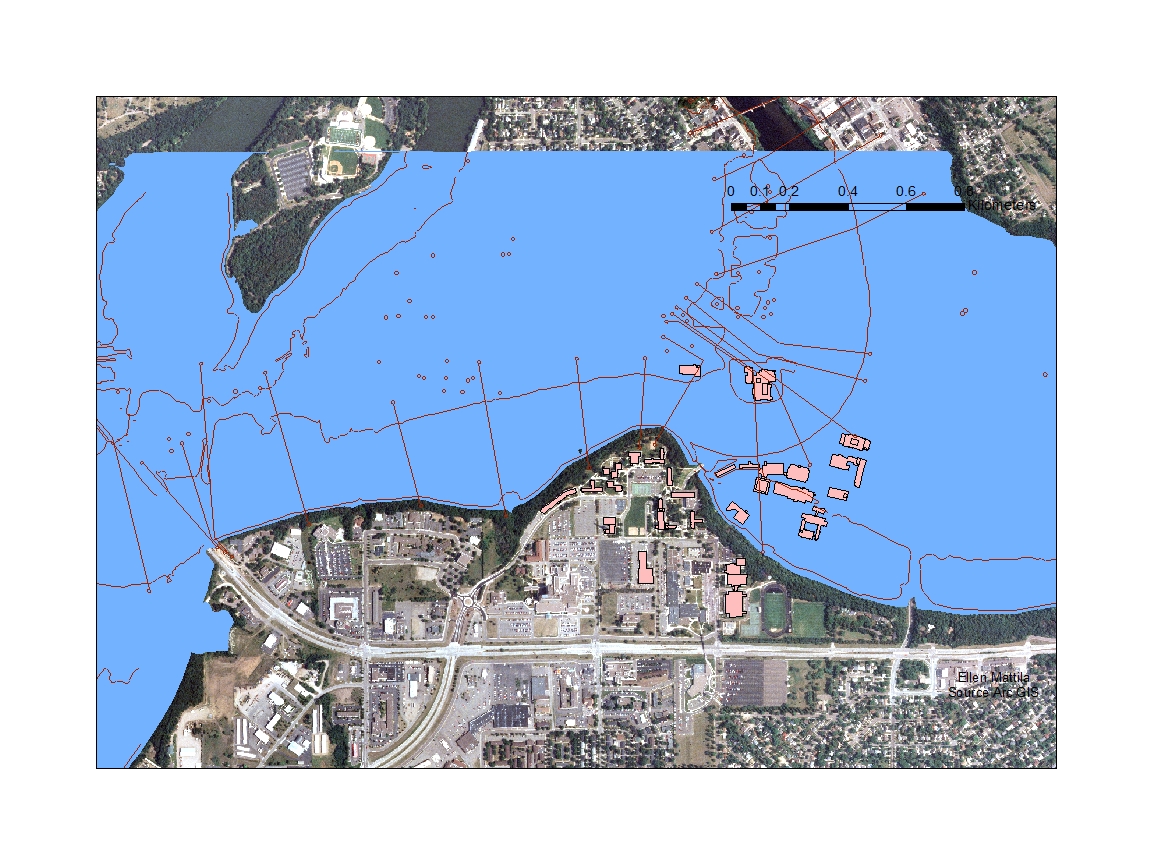
| A 750 foot flood of the Chippewa River in Eau Claire and on the UWEC campus. Modeled in ArcGIS. |
 | |
|
 |
| Drought in the United States. Modeled with ArcGIS using the Palmer Drought Severity Index. |
 |
| Doppler Radar data showing rainfall over a given area. Rainfall data helps to understand slope failure. Modeled with ArcGIS. |
 |
| Slope failure in Forest Falls, modeled with ArcGIS. |
 |
| Category 3 hurricane surge. ArcGIS. |
 |
| Soil liquefaction and building damage in the Northridge Earthquake. ArcGIS. |
 |
| Northridge Earthquake. ArcGIS. |
 |
| Soil type and Crop Yields. ArcGIS. |
 |
| Tectonic plates, plate directions and volcanoes. ArcGIS. |
 |
| Mount Saint Helens after the blast. ArcGIS. |
 |
| Mount Saint Helens before the blast. ArcGIS. |
 |
| Areas of signifigant earthquake risk |
 |
| Landmass volume gain and loss after Mount Saint Helens eruption. |
 |
| 100 year flood of the Chippewa River in Eau Claire. ArcGIS. |
 |
| Elevation around mount Rainier. |
 |
| Lahar flows around mount Rainier. |
 |
| Landslide risk in the USA. ArcGIS |
 |
| Slope severity. |
 |
| Tsunami inundation in Oxnard California. ArcGIS |
 |
| Slope volume loss form Mount Saint Helens explosion. |
 |
| Palmer Drought Severity Index from ArcGIS online |

Stop Disasters Game: Tsunami Disaster Mitigating Strategies
Attempt 1: Keep people alive. My strategy was to reinforce the waterfront as much as possible, build homes on high ground away from the waterfront, and provide safe places for the people to go to. I even demolished some bamboo huts and relocated people to sturdier buildings. I overlooked that there were upgrades to certain buildings like education plans, radio systems and evacuation plans. I could have educated my people more and gotten more people out of town. 16 people died and 16 were injured.
 |
| In this image you can see that I added mangroves to protect against flooding and I put my important buildings on high ground to keep them safer from the tsunami's flood waters. |
 |
| In this image you can see that I added dunes to the beach to help break the waves as they make landfall. I also provided more housing on high ground to get people out of bamboo huts on the beach. |
Attempt 2: Kill them all. My strategy for this round was to eliminate as many of the natural barriers to a tsunami as possible. I created more beachfront by uprooting all the mangroves. I also built shoddy housing on the waterfront. I killed 76people and 76 were injured.
 |
| In this image you can see that I removed all the mangroves to create a beautiful beachfront and I placed some housing and a hotel on the new, scenic, deadly, unprotected beach. |
 |
| In this image you can see that I placed lots of cheap flimsy housing on on the lowlands close to the ocean. |
No comments:
Post a Comment